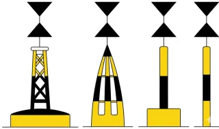
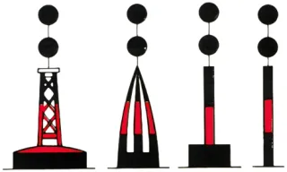
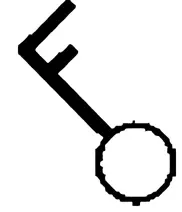
Question 156 · Specific question Coastal
What are fairways (Fahrwasser) within the meaning of the Maritime Waterways Regulations (SeeSchStrO) and the Ems Estuary Traffic Regulations (EmsSchO)?
- A Waters continuously bounded or marked by lateral fairway marks, and inward from river mouths also unmarked waters designated for through navigation. Correct
- B Waters approved for seagoing vessels; inward from river mouths inland vessels and pleasure craft are also permitted.
- C Waters continuously bounded or marked by lateral fairway marks on which water-skiing and jet skiing are permitted provided through traffic is not impeded.
- D Waters continuously bounded or marked by lateral fairway marks on which the Pleasure Craft Licence Regulations apply.
Explanation by Boatpass
For the purposes of the German Maritime Waterways Regulations (SeeSchStrO), fairways are waters continuously bounded or marked by the prescribed lateral fairway marks.
Question 157 · Specific question Coastal
Which is the starboard side of a fairway (other than in tidal flat areas)?
- A The side that a vessel coming from seaward has on her starboard side. Correct
- B The side that a vessel coming from seaward has on her port side.
- C The side marked with red buoys when coming from seaward.
- D The side where buoys are marked with consecutive even numbers.
Explanation by Boatpass
Outside tidal-flat areas, the starboard side of a fairway is the side that a vessel approaching from seaward has on her starboard side.
Question 169 · Specific question Coastal
Where may water-skiing, personal watercraft riding, or windsurfing take place?
- A Outside the fairway, provided it has not been prohibited by the General Directorate of Waterways and Shipping (GDWS) by official notice. Within the fairway, on sections published by the GDWS or marked by blue signs bearing the white symbol of a water-skier, personal watercraft, or windsurfer. Correct
- B Outside the sea waterway, provided it has not been prohibited by the GDWS by official notice. Within the sea waterway, on sections published by the GDWS or marked by blue signs bearing the white symbol of a water-skier, personal watercraft, or windsurfer.
- C On the high seas and on connected waters navigable by seagoing vessels, provided a minimum distance of 100 m from the shore is maintained.
- D Within the fairway, provided it has not been prohibited by the GDWS by official notice. Outside the fairway, on sections published by the GDWS or marked by blue signs bearing the white symbol of a water-skier, personal watercraft, or windsurfer.
Explanation by Boatpass
Water-skiing, operating a personal watercraft and windsurfing are permitted outside the fairway unless the area has been closed by an official notice.
Question 170 · Specific question Coastal
How must the skippers of towing craft for water-skiers, personal watercraft riders, and windsurfers behave when approaching other vessels?
- A They must give way. Correct
- B They must stop when approaching other vessels and avoid creating suction or wash.
- C They have right of way and must cross ahead of the other vessel.
- D They must maintain their course and speed.
Explanation by Boatpass
Operators of towboats for water-skiers and towed water-sports equipment, operators of personal watercraft, and kite- and windsurfers must keep out of the way of all vessels.
Question 171 · Specific question Coastal
Where is anchoring prohibited?
- A In the fairway, at narrow passages and blind bends; within 300 m of floating equipment, wrecks and other navigation hazards, cable buoys and other sites used for military and civil purposes; in front of harbour entrances, locks, landing stages, and tidal sluices, and in the approaches to the Kiel Canal; within ferry and bridge stretches; and 300 m before and beyond no-anchoring signs. Correct
- B In the fairway, on sea waterways, at narrow passages and blind bends; within 300 m of floating equipment, wrecks and other navigation hazards, cable buoys and other sites used for military and civil purposes; in front of harbour entrances, locks, landing stages, and tidal sluices, and in the approaches to the Kiel Canal; within ferry and bridge stretches; and 300 m before and beyond no-anchoring signs.
- C In the fairway, at narrow passages and blind bends; within 300 m of floating equipment, cable buoys and other sites used for military and civil purposes; in front of harbour entrances, locks, landing stages, and tidal sluices, and in the approaches to the Kiel Canal; and in bird sanctuaries, nature conservation areas, and generally throughout national parks.
- D In the fairway, if published by the General Directorate of Waterways and Shipping (GDWS). Outside the fairway, on sections published by the GDWS or marked by the relevant signs.
Explanation by Boatpass
Anchoring is prohibited in the fairway, at narrow places and in blind bends; within 300 metres of floating equipment, wrecks and other obstructions, cable buoys and special sites; off …
Question 172 · Specific question Coastal
What must be done to warn other vessels when your own craft has sunk and constitutes a navigation hazard?
- A Inform the maritime traffic authority and provide the position if possible. Correct
- B Inform the German Maritime Search and Rescue Society so that the hazard can be marked.
- C Send out a distress signal.
- D Inform the Federal Maritime and Hydrographic Agency (BSH) and provide the position if possible.
Explanation by Boatpass
If your own vessel has sunk and constitutes a navigation hazard, the maritime traffic authority must be informed and the exact position provided as accurately as possible.
Question 173 · Specific question Coastal
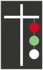
On which signal may pleasure craft enter the locks of the Kiel Canal (NOK)?
- A When an interrupted white light is displayed. Correct
- B When a white flashing light is displayed.
- C When two green lights are shown side by side.
- D When a green isophase light is displayed.
Explanation by Boatpass
Pleasure craft may enter the locks of the Kiel Canal when an interrupted white light is displayed.
Question 174 · Specific question Coastal
Where can rules for navigating the Kiel Canal (NOK) be found?
- A Supplementary provisions for the NOK in the German Maritime Waterways Regulations (SeeSchStrO) and in the official notices of the General Directorate of Waterways and Shipping (GDWS). Correct
- B Supplementary provisions for the NOK in the German Maritime Waterways Regulations (SeeSchStrO) and in the Collision Regulations (COLREGs).
- C Supplementary provisions for the NOK in the German Maritime Waterways Regulations (SeeSchStrO) and in the Pleasure Craft Licence Regulations.
- D Supplementary provisions for the NOK in the German Maritime Waterways Regulations (SeeSchStrO) and in the Maritime Functions Act.
Explanation by Boatpass
Rules for the Kiel Canal (NOK) are found in the supplementary provisions of the German Maritime Waterways Regulations (SeeSchStrO) and in the official notices of the General Directorate of …
Question 175 · Specific question Coastal
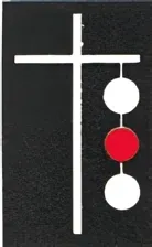
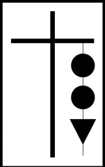
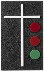
What do three interrupted red lights displayed vertically on a junction signal mast in the Kiel Canal mean, and what must be observed?
- A Exit prohibited for all vessels; wait for the signal to be cancelled. Correct
- B Protected installation; reduce speed, avoid suction and wash.
- C Permanent closure of the sea waterway; further passage prohibited.
- D Permanent closure of a section of the sea waterway; further passage in that section prohibited.
Explanation by Boatpass
Three occulting red lights displayed vertically on a passing-place exit signal mast in the Kiel Canal mean that exit is prohibited for all vessels.
Question 176 · Specific question Coastal
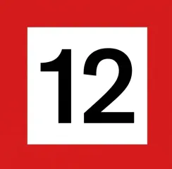
What is the meaning of the following sign?
- A The speed through the water in km/h — on the Kiel Canal (NOK) over the ground in km/h — that must not be exceeded. Correct
- B Minimum distance in metres that must be maintained in the subsequent section from the point where the sign is erected.
- C The speed through the water in knots (kn) — on the Kiel Canal (NOK) over the ground in knots — that must not be exceeded.
- D Minimum distance to other vessels in metres that must not be undercut in the published section.
Explanation by Boatpass
Sign A.3 states the maximum speed in kilometres per hour.
Question 177 · Specific question Coastal
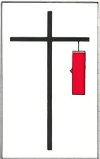
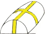
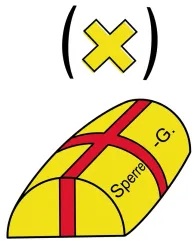
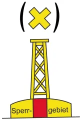
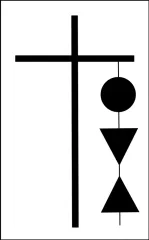
What is the meaning of the following day shapes?
- A Protected installation. Correct
- B Permanent closure of a section of the sea waterway.
- C Permanent closure of the sea waterway.
- D Extraordinary obstruction to navigation.
Explanation by Boatpass
The visual signals mark an installation requiring protection.
Question 179 · Specific question Coastal
What is the meaning of the following day shape?
- A Speed of 8 km/h through the water that must not be exceeded within a distance of 500 m from the respective shoreline due to bathing activity. Correct
- B Marking of special areas and places, e.g. warning areas; the meaning can be found in the chart and read from the labelling on the navigation mark.
- C Speed of 8 knots through the water that must not be exceeded within a minimum distance of 500 m from the respective shoreline due to bathing activity.
- D Groin structure; hazard from suction and wash. Pay particular attention to bathers and swimmers.
Explanation by Boatpass
Visual sign A.5 means that, because of bathing activity, speed through the water must not exceed 8 kilometres per hour within the 500-metre shore zone.
Question 180 · Specific question Coastal
What is the meaning of the following navigation mark?
- A Closed to all power-driven vessels and personal watercraft due to bathing activity. Correct
- B Maximum speed of 4.3 knots through the water that must not be exceeded within 500 m from the respective shoreline due to bathing activity.
- C Isolated danger mark; identifiable by its colouring, which can be passed on all sides at a maximum speed of 4.3 knots.
- D Marking of special areas and places, e.g. warning area.
Explanation by Boatpass
The sign marks a bathing area closed to power-driven vessels and personal watercraft.
Question 181 · Specific question Coastal
What maximum speed must not be exceeded in front of areas with recognisable bathing activity — outside the fairway — within a distance of 500 m or less from the shore?
- A 4.3 knots. Correct
- B 3.4 knots.
- C 4.8 knots.
- D 3.8 knots.
Explanation by Boatpass
Off recognisable bathing activity outside the fairway, within 500 metres or less from the shore, the maximum speed is 4.3 knots through the water (equal to 8 kilometres per hour).
Question 182 · Specific question Coastal
What is the meaning of the following navigation mark?
- A Marking of special areas and places. Correct
- B Marking of prohibited areas.
- C Marking of firing ranges.
- D Marking of bathing areas.
Explanation by Boatpass
This navigation mark indicates special areas and places, for example nature reserves, exercise areas, or other designated zones.
Question 183 · Specific question Coastal
How can a military warning area closed to navigation due to firing exercises be recognised?
- A By specific day and night signals shown at signal stations and on guard vessels in accordance with the Prohibited and Warning Areas Ordinance of the General Directorate of Waterways and Shipping (GDWS). Correct
- B By specific day and night signals shown at signal stations on the shore and on guard vessels in accordance with the Rhine Police Regulations of the GDWS.
- C By specific day and night signals shown at signal stations on the shore and on guard vessels in accordance with the relevant police ordinance of the Water Management Authority.
- D By specific day and night signals shown at signal stations on the shore and on guard vessels in accordance with the Traffic Regulations of the GDWS.
Explanation by Boatpass
Military warning areas are marked by specific day and night signals in accordance with the Prohibited and Warning Areas Ordinance.
Question 184 · Specific question Coastal
What is the meaning of the following navigation marks?
- A Prohibited area. Correct
- B Prohibited area and bathing zone.
- C Prohibited area due to aquacultures and mussel farming installations.
- D Firing range.
Explanation by Boatpass
The prohibited area sign indicates that this area is closed to navigation (temporarily or permanently).
Question 185 · Specific question Coastal
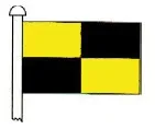
What is the meaning of the following flag signal?
- A Stop. Correct
- B Distress signal.
- C Anchor obstructing navigation.
- D Tow over 200 m.
Explanation by Boatpass
The letter L shown as a light signal, or International Code flag L, displayed by a public-service vessel orders the vessel addressed to stop.
Question 187 · Specific question Coastal
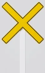
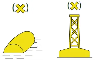
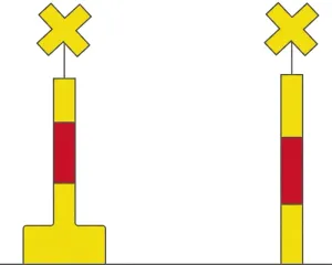
What is the meaning of the following day shapes?
- A Permanent closure of the sea waterway. Further passage prohibited. Correct
- B Protected installation. Avoid suction and wash.
- C Extraordinary obstruction to navigation. Pass with caution.
- D End of a mandatory or prohibited stretch. Free to continue.
Explanation by Boatpass
The signal indicates the permanent closure of the sea waterway; further passage is prohibited.
Question 189 · Specific question Coastal
What is the meaning of the following day shapes?
- A Extraordinary obstruction to navigation. Correct
- B Permanent closure of the sea waterway.
- C Protected installation.
- D Temporary closure of the sea waterway.
Explanation by Boatpass
Visual signals B.6 mean 'extraordinary obstruction to navigation'.
Question 190 · Specific question Coastal
What is the meaning of the following buoy?
- A Marking the centre of shipping lanes. Correct
- B Marking of isolated danger points.
- C Marking of a roadstead.
- D Marking the port side of a fairway.
Explanation by Boatpass
Mark B.10 indicates the seaward approach to a fairway or the centre of a navigable channel.
Question 191 · Specific question Coastal
What is the meaning of the following navigation mark?
- A The starboard side of the fairway. Correct
- B The port side of the fairway.
- C The centre of a shipping lane.
- D Marking of obstructions.
Explanation by Boatpass
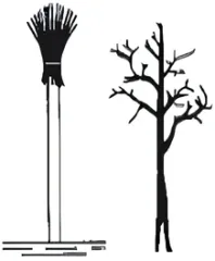
In tidal fairways the starboard side is marked by a withy in fir-tree form: the twigs are bound at the top and splayed apart at the bottom, forming a pointed shape (colloquially a fir tree, “Tanne”).
Question 192 · Specific question Coastal
What is the meaning of the following navigation mark?
- A The port side of the fairway. Correct
- B The starboard side of the fairway.
- C The centre of a tidal fairway.
- D The marking of an obstruction in a tidal fairway.
Explanation by Boatpass
This withy has its twig bundle tied at the bottom, with the branches splaying out above in a blunt, broom-like shape, usually carrying a red band.
Question 193 · Specific question Coastal
What is the meaning of the following buoy/navigation mark?
- A The starboard side of the fairway. Correct
- B The port side of the fairway.
- C The centre of a shipping lane.
- D The marking of obstructions.
Explanation by Boatpass
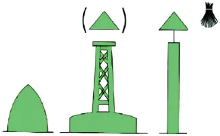
The green mark indicates the starboard side of the fairway in the conventional direction of buoyage.
Question 194 · Specific question Coastal
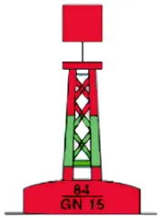
What is the meaning of the following buoy/navigation mark?
- A The port side of the fairway. Correct
- B The starboard side of the fairway.
- C The centre of a tidal fairway.
- D The marking of an obstruction in a tidal fairway.
Explanation by Boatpass
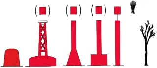
In Region A of the International Organization for Marine Aids to Navigation (IALA), a red lateral mark, with a red light if lit, marks the port side of the fairway in the conventional …
Question 195 · Specific question Coastal
What is the meaning of the following buoy?
- A Starboard side of the main fairway / port side of the branching or joining fairway. Correct
- B Port side of the main fairway / starboard side of the branching or joining fairway.
- C Starboard side of the main fairway.
- D Port side of the main fairway.
Explanation by Boatpass
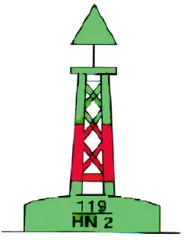
The starboard side of the main fairway (and at the same time the port side of the branching fairway) is marked by a green-red-green banded preferred-channel buoy: green body with a broad …
Question 196 · Specific question Coastal
What is the meaning of the following buoy?
- A Port side of the main fairway, starboard side of the branching or joining fairway. Correct
- B Starboard side of the main fairway, port side of the branching or joining fairway.
- C Starboard side of the main fairway.
- D Port side of the main fairway.
Explanation by Boatpass
The port side of the main fairway (and at the same time the starboard side of the branching fairway) is marked by a red-green-red banded preferred-channel buoy: red body with a broad green …
Question 197 · Specific question Coastal
What is the meaning of the following light characteristic: 'Oc (2) R. Whis.'?
- A Occulting (2) red, whistle buoy. Correct
- B Flashing (2) red, bell buoy.
- C Quick flashing (2) red, bell buoy.
- D Leading light red, two warning sectors.
Explanation by Boatpass
The notation describes a red group-occulting light with two eclipses in each group on a buoy fitted with a wave-actuated whistle (Oc(2) R.
Question 198 · Specific question Coastal
What light characteristics and colour do the lights of lit buoys on the starboard side of the fairway have?
- A Green flashing, quick flashing, or occulting light in groups. Correct
- B Green flashing, quick flashing, or fixed light.
- C Green flashing, quick flashing, or very quick flashing light.
- D Green flashing, quick flashing, or morse-code light.
Explanation by Boatpass
Lighted buoys on the starboard side of the fairway show a green light – as a flashing, quick-flashing or group-occulting light.
Question 199 · Specific question Coastal
What light characteristics and colour do the lights of lit buoys on the port side of the fairway have?
- A Red flashing, quick flashing, or occulting light in groups. Correct
- B Red flashing, quick flashing, or fixed light.
- C Red flashing, quick flashing, or very quick flashing light.
- D Red flashing, quick flashing, or morse-code light.
Explanation by Boatpass
Lighted buoys on the port side of the fairway show a red light – as a flashing, quick-flashing or group-occulting light.
Question 200 · Specific question Coastal
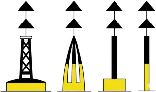
What is the meaning of the following navigation mark?
- A Marking of a general danger, north quadrant. Correct
- B Marking of a general danger, south quadrant.
- C Marking of a general danger, west quadrant.
- D Marking of a general danger, east quadrant.
Explanation by Boatpass
The north cardinal mark indicates: the danger lies to the south of this buoy; the water to the north is clear.
Question 201 · Specific question Coastal
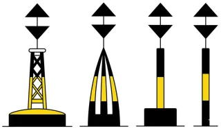
What is the meaning of the following navigational mark?
- A Marking a general hazard, east quadrant. Correct
- B Marking a general hazard, north quadrant.
- C Marking a general hazard, west quadrant.
- D Marking a general hazard, south quadrant.
Explanation by Boatpass
The east cardinal mark indicates: the hazard lies to the west of this buoy, the east side is clear.
Question 202 · Specific question Coastal
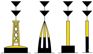
What is the meaning of the following navigational mark?
- A Marking a general hazard, south quadrant. Correct
- B Marking a general hazard, north quadrant.
- C Marking a general hazard, west quadrant.
- D Marking a general hazard, east quadrant.
Explanation by Boatpass
The south cardinal mark indicates: the hazard lies to the north of this buoy, the south side is clear.
Question 203 · Specific question Coastal
What is the meaning of the following navigational mark?
- A Marking a general hazard, west quadrant. Correct
- B Marking a general hazard, east quadrant.
- C Marking a general hazard, north quadrant.
- D Marking a general hazard, south quadrant.
Explanation by Boatpass
The west cardinal mark indicates: the hazard lies to the east of this buoy, the west side is clear.
Question 208 · Specific question Coastal
What does one of the following navigational marks indicate and what behaviour is required?
- A An isolated danger mark that can be passed on all sides. Correct
- B The north quadrant of a general hazard that must be passed to the north.
- C The south quadrant of a general hazard that must be passed to the south.
- D The west quadrant of a general hazard that must be passed to the west.
Explanation by Boatpass
An isolated danger mark indicates a single, isolated hazard (for example a solitary reef) that can be passed on all sides.
Question 260 · Specific question Coastal
What does the following symbol mean?
- A Wind from the northwest; force: Bft. 3; clear sky. Correct
- B Wind towards the northwest; force: Bft. 3; clear sky.
- C Current from the northwest; speed: 3 knots; tidal area.
- D Current towards the northwest; speed: 3 knots; tidal area.
Explanation by Boatpass
The weather symbol denotes wind from the northwest, Beaufort force 3 and a clear sky.
 Boat